Huangbaiyu The Place
the valleys and villages...continued
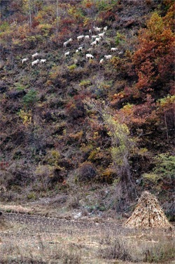
The white dots scattered across the slopes to the west and cliffs to the east belong to those for whom the land of Huangbaiyu must work. Twice a day in short months when it is not winter, the goats are taken into the mountains to browse on leaves and shoots, so that after the long winter, their cashmere can be combed, and a family can be fed for the next year.
The houses reach right up the to edge of the road, and lorries heaving with iron ore, rock, sand and shale spray dust on drying clothes and have killed a 12 year old girl and 44 year old father here recently. There can be no speed bumps because this road is a National Road, and national roads are priority conduits for trade and transport even when they cut villages in half. There are two small convenience stores in Zhao Family Riverside, directly across the street from each other.
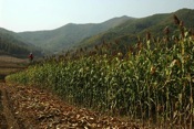
The houses end abruptly, and the valley is fills with maize. Just after tilling, each family’s farm land is made visible by the spacing and angle of their plowed rows, but even when the maize is waist high at the height of summer, the eye can discern the hundreds of small holdings that cover every inch of valley land, and high up the slopes.
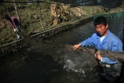
A centipede, each segment a rectangular pool full of swirling rainbow or golden trout, stretches through the middle of the western valley, connecting Zhao Family Riverside with a hamlet that cannot decide if its proper name is the Neighborhood of the Imperial Family or the Neighborhood of the Huang Family. Residents of this hamlet are not disturbed by the two competing names, not only because in Chinese “imperial” (皇) and “huang” (黄) are homonyms, but also because at least in these mountains of old Manchuria, they are considered synonyms. The man who renamed the nascent Later Jin dynasty to Qing, and became the first emperor of the Manchurian dynasty that would invade China and rule it for 267 years is known in these valleys as Huang Taiji (黄台吉)--the auspicious foundation for the rise of the newly united Manchus from disparate hunting tribes to a continental power. Local stories tell of his hunting in these mountains, and seeking refuge from Ming Dynasty troops in their ravines. Thus the hamlet can thought of as the imperial neighborhood for the Qing Dynasty’s first emperor without any confusion at all. The imperial interpretation is also favored by families with the surname Huang who reside here, as it gives a royal history to what might otherwise just be another village named according to the dominant surname in the area.
Of course, after the Communists began governing these lands, all place names with odes to imperial or clan histories were eliminated. This hamlet, and the people living here, became simply known as Production Team Three. The valley was then full of sorghum or maize, as dictated by government planning, and sowed, tended and harvested in communal holdings by Production Team Three. State quotas for grain were filled, and the remainder was kept and distributed amongst families. Then what would become National Road 304 followed the topography of the valley, holding close to the river.
But now the road has moved away from the homes. It is the river now that acts as the main link between the homes here, nestled in the shadow of the western slopes, and the world beyond the mountains. After the communes were divided back into family plots, households could decide for themselves how to support their families. By the early 1990’s a few families began experimenting with raising rainbow trout in the cold, clear waters tumbling from the mountains’ slopes. To be continued...
Copyright © 2008-2009 Shannon May About me Design Blog Kenya & Life Sundries Blog Contact smay at post dot harvard dot edu
Everything is a work in progress